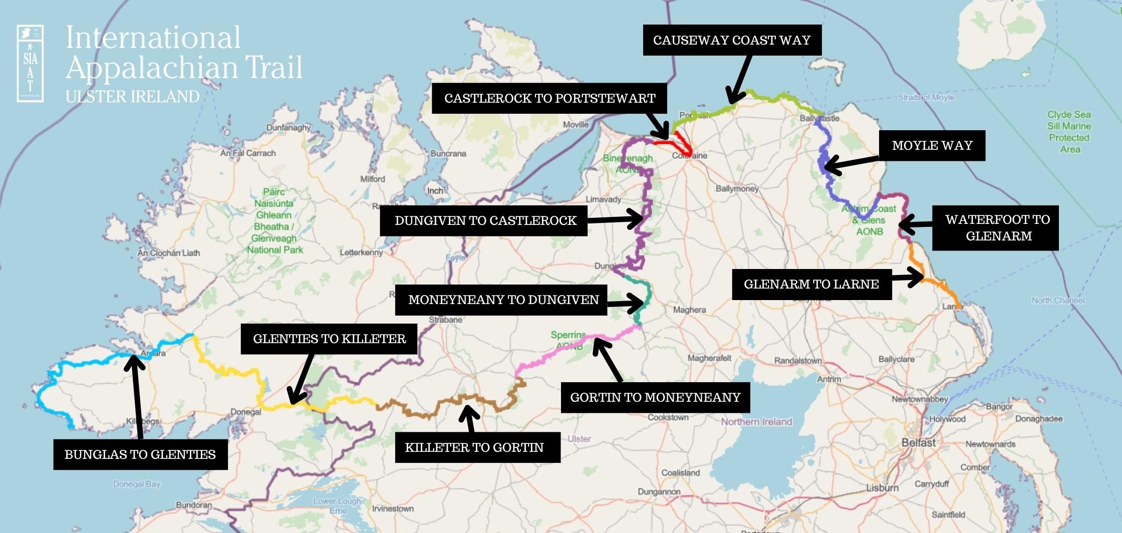
If you want to ‘thru-hike’ the IAT Ulster-Ireland this is how we suggest you complete it.
The official start point of the IAT Ulster-Ireland is Sliabh Liag in County Donegal with the route travelling east into Co. Tyrone, Co. Derry~Londonderry and Co. Antrim where the trail finishes at Larne on the east coast of Northern Ireland. We recommend following this route from West to East. The following sections are divided between waymarked routes and non waymarked routes. We would advise that on the non waymarked routes, which follow mainly public roads, you take public transport.
From the point of Larne you will see a sign at the end of the route to progress onto the next Chapter of the International Appalachian Trail in Scotland just a short boat ride from Larne.
 The ‘more information’ links below take you to another website but they open in a new tab so you can easily find your way back to this website.
Bunglas to Glenties
This section is the first stretch of the IAT Ulster-Ireland, following the Atlantic Coast from Bunglas, past Slieve League, Glencolmcille, Ardara and ending at Glenties.
Distance – 42 miles (67.5km) | More Information
Glenties to Killeter
This section travels through County Donegal from the town of Glenties, passing Lough Eske and crossing the Northern Ireland Border into County Tyrone before ending in the village of Killeter.
Distance: 34 miles (55km) | More Information
Killeter to Gortin
The trail picks up the Ulster Way on this section, a 636 mile circular walking route of Ulster. You will follow quiet country roads, walk across open mountain side with view of the Sperrin Mountains, before reaching Gortin Forest Park.
Distance: 36 miles (58km) | More Information
Gortin to Moneyneany
The Sperrin Mountains form the largest area of upland in Northern Ireland. This 23-mile section of the Ulster Way journeys through the heart of the range, mainly following quiet roads and tracks. The highlight is the middle portion through the exceptionally scenic Glenelly Valley. From the head of the valley, walkers who wish to shorten the final road section to Moneyneany can use the public bus service along the B47.
Distance: 23 miles (37km) | More Information
Moneyneany to Dungiven
This section travels through forest and across open hillside and offers some fantastic views. Great views of the Roe Valley and the historic town of Dungiven can be enjoyed.
Distance: 13 miles (21km) | More Information
Dungiven to Castlerock
From the main spine of the Sperrin Mountains a broad ridge of rolling upland stretches north all the way to the north coast. The North Sperrins Way makes up the majority of this route following the crest of this ridge from the historic town of Dungiven all the way to Swann’s Bridge near Binevenagh. It then continues further to Castlerock on the north coast. Along the way the route enjoys fine views and a variety of walking, from open mountainside to forest trails and quiet roads.
Distance: 37.5 miles (60km) | More Information
Castlerock to Portstewart
This section is not waymarked and mainly on public roads some of which can be very busy. Walkers are actively encouraged to make use of public transport along this section so they can make best use of their time on the more attractive waymarked sections.
This section is on mainly quiet rural roads between Castlerock and Coleraine. The section from Coleraine to Portstewart follows the busy A2 road.
Distance: 10 miles (16km) | More Information
Causeway Coast Way
This route section, from Portstewart to Ballycastle, passes through the Causeway Coast Area of Outstanding Natural Beauty, a World Heritage Site and several Areas of Special Scientific Interest. It includes views of wide bays, sandy beaches, dramatic cliffs and off-shore rocks.
Distance: 33 miles (52km) | More Information
Moyle Way
Taking the walker through a magnificent land of geology, wildlife, history and folklore, this route passes a wealth of rivers, ancient monuments and exposed hill summits before reaching its end in the beautiful Glenariff Forest Park.
Distance: 27 miles (43km) | More Information
Waterfoot to Glenarm
This section is not waymarked and mainly on public roads some of which can be very busy. Walkers are actively encouraged to make use of public transport along this section so they can make best use of their time on the more attractive waymarked sections.
Distance: 12 miles (19km) | More Information
Glenarm to Larne
Crossing some the most scenic upland areas in the Antrim Glens, this route offers fantastic views that encompass much of Northern Ireland, as well as extending across the sea to Scotland. Despite being signed throughout, the open terrain means you should take all the normal precautions associated with mountain walking.
Distance: 14 miles (22.5km) | More Information