Overview
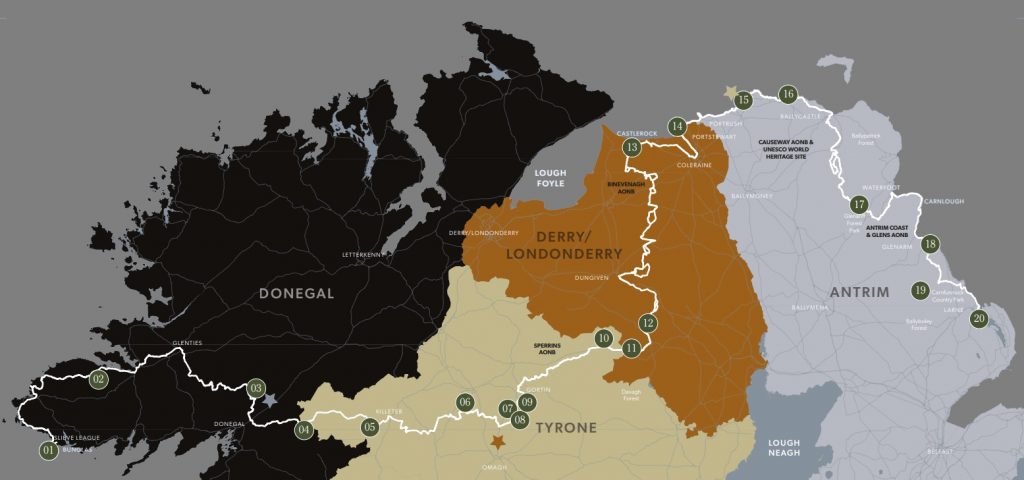
Starting at the spectacular cliffs of Sliabh Liag, the trail runs from west Donegal in the Republic of Ireland and passes the wide-open spaces of the Sperrins, rugged Causeway Coast and across the magnificent Glens of Antrim to Larne, Co. Antrim in Northern Ireland.
Spanning 279 miles, the route takes walkers through some wonderfully diverse landscapes which can be walked as a ‘thru-hike’, completed in stages or enjoyed as part of a day walk.
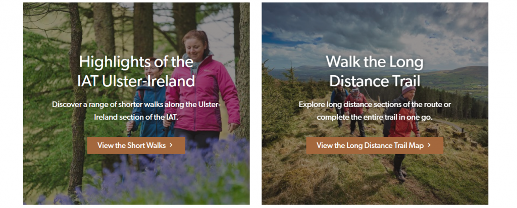
To help you find the information you need, depending on how much of the IAT Ulster-Ireland route you want to walk, this website has been split into the following two areas:
- Highlights of the IAT Ulster-Ireland – for those wanting information on a range of shorter circular or linear walks either on or close to the IAT Ulster-Ireland route.
- Walk the Long Distance Trail – for those wanting to walk longer distances of the IAT Ulster-Ireland route over a full day, multiple days or weeks.
The Organisation
History
The Appalachian Mountains were formed more than 250 million years ago when the earth’s plates collided to form the supercontinent of Pangaea. When today’s continents separated remnants of the Appalachians ended up in eastern United States, eastern Canada, Greenland, Iceland, the British Isles, Ireland, the Iberian Peninsula, and the Atlas Mountains of Morocco.
The Appalachian Trail (AT) runs over 3,000 miles from Georgia in the south of the United States of America to its northern terminus on Mount Katahdin in Maine, stopping short of the Canadian border. In 1994 the idea to continue a trail along the remnants of the Appalachian-Caledonian Mountains across the political border into Canada was proposed and the International Appalachian Trail (IAT) was born.
By 2009 consideration was being given to extending the IAT. Greenland became the first chapter outside of North America followed closely by Scotland. There are now IAT Chapters in Maine, New Brunswick, Quebec, Nova Scotia, Prince Edward Island, Newfoundland & Labrador, Greenland, Iceland, Ireland, Scotland, England, Isle of Man, Wales, Norway, Spain, Portugal, and Morocco.
The Ulster-Ireland Chapter of the International Appalachian Trail was officially launched in 2013 and measures approximately 279 miles/449km.
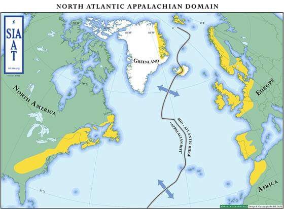
The Appalachian Mountains – 250 million years ago and today
Mission of the IAT
The ultimate mission of the IAT is to establish a network of walking trails that extends beyond borders to all geographic regions once connected by the ‘Appalachian-Caledonian orogen’. In addition to connecting places and people, the IAT aims also to promote natural and cultural heritage, health and fitness, environmental stewardship, fellowship and understanding, cross-border cooperation, and rural economic development through eco and geo tourism.
The IAT continues to expand into areas of the old Appalachian terrains, based on the original premise that the trail will eventually connect all the mountains that were created when the ancient continent Pangaea was formed. When expansion is complete, the IAT will be the largest trail network and one of the largest outdoor adventure brands in the world – with a presence in 21 ‘countries’ across three continents and with a home market of over 800 million people.
Partners
The IAT Ulster-Ireland crosses five council areas in Northern Ireland including Fermanagh and Omagh, Derry and Strabane, Causeway Coast and Glens, Mid Ulster and Mid and East Antrim as well as Donegal in Southern Ireland.
The development needs of the route are serviced through the activities of a steering group comprising interested persons and parties from the local and national government sector as well as the voluntary and private sectors. To date the group has overseen a number of landmark events and activities which include:
- Formal launch in August 2013 at the Ulster American Folk Park, Omagh
- Long distance hiker Joe Norman, trail name “Cotton Joe”, from North Carolina became the first walker to complete the route in September 2013
- Strabane (Co. Tyrone) hosted the IAT AGM in September 2016
- Engagement with Appalachian Mountain Club and Appalachian Trail Conservancy at Boston trade event in November 2016
- Engagement in the delivery of a Scoping Study Report of the Ulster-Ireland Section of the International Appalachian Trail funded by the RDP and delivered by Outdoor Recreation NI
- Hosted a visit for the Appalachian Mountain Club and Appalachian Trail Conservancy in Ireland in June 2019
There is also a working group which includes representatives from the partner Local Action Groups (LAGs) in each council area and Donegal who have come together to scope, develop and deliver a rural cooperation project through the Rural Development Programme 2014-2020.
Rural Development Programme 2014-2020 Project
Investment in the Ulster-Ireland segment of the International Appalachian Trail is the result of six Local Action Groups (LAGs) who administer Rural Development Programme funding for their area, working together on a joint initiative as part of a cooperation project to develop and enhance the trail. The participating LAGs include Derry and Strabane, Causeway Coast and Glens, Fermanagh and Omagh, Mid Ulster, Mid and East Antrim and Donegal. Capital investment on the trail has been spent on improving the overall visitor experience by upgrading or rerouting the trail, overhauling trail infrastructure and signage as well as adding trail furniture and trail art.
This coordinated approach to creating an internationally recognised product is being supplemented by additional investment in a marketing project to promote the trail to walkers in Northern Ireland, the Republic of Ireland and the USA and has included the development of this website.
The Route
Signage
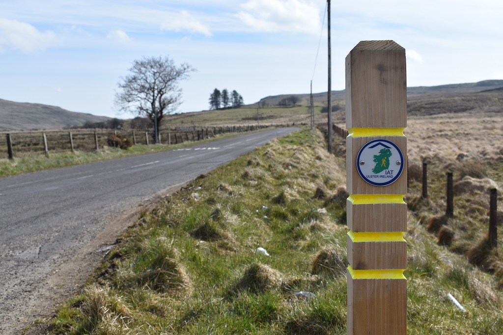
Signage for the IAT Ulster-Ireland is the same in each county featuring a yellow walker and map of Ireland.
Within the Causeway Coast and Glens Borough, the IAT Ulster-Ireland route follows the route of the Ulster Way, which is signed and waymarked using the existing Ulster Way & Waymarked Ways signage. Occasional rectangular IAT markers are affixed to certain items of trail furniture along the route to provide reassurance for visiting walkers.
Accessibility
The IAT Ulster-Ireland route takes in a wide range of terrains including steep cliff paths, forest tracks, open mountain and glens and quiet country roads. Those looking to explore the trail with limited mobility should check the accessible grades (see an overview of the grades below) by clicking on the ‘more info’ links in the pop up boxes on the Long Distance Trail Map (for longer walks) or on the Short Walks Map (for shorter walks) are suitable before visiting. Please note the full route is challenging and we recommend that only those with a good level of fitness and who have confidence and experience in outdoor environments where the weather can change dramatically should take on the full route.